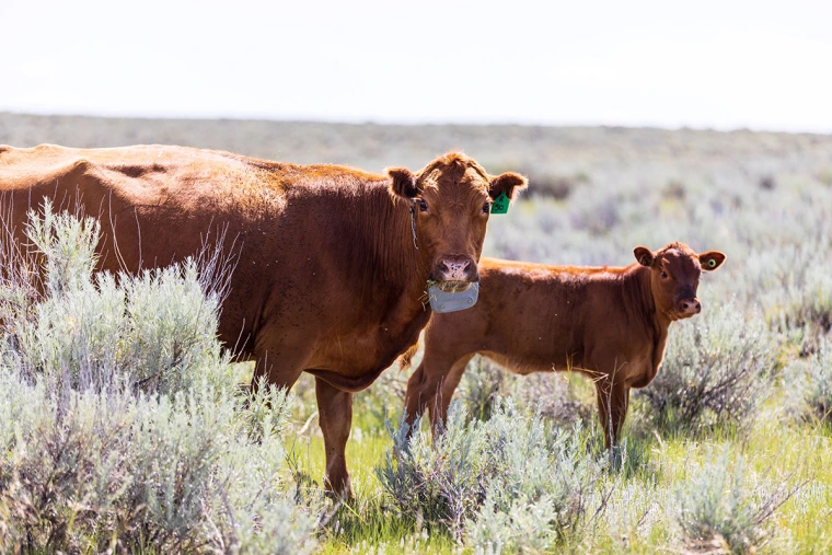
Listen to Jay Smith, a rancher in Idaho, and Joel Yelich, a University of Idaho researcher, describe their experience managing cattle on a 100,000 acre U.S. Forest Service grazing permit that had burned the year before. Jay was able to keep grazing the permit because virtual fence allowed him to keep cattle off the burn footprint without putting up barbed wire or hotwire. Most rangeland grazing problems are related to animal distribution, and wireless fence may prove to be a game-changing distribution technology, almost a back-to-the-future approach to managing livestock distribution on large landscapes, places where physical fence is not feasible or advisable anymore. Virtual fence can enable effective herding on land with challenging topography and vegetation.
This episode is sponsored by the Idaho Rangeland Resources Commission and Life on the Range: idrange.org/life-on-the-range/.
Transcript
<p>[ Music ]</p>
<p>>> Welcome to The Art of Range, a podcast focused on rangelands and the people who manage them. I'm your host, Tip Hudson, Range and Livestock Specialist with Washington State University Extension. The goal of this podcast is education and conservation through conversation. Find us online at artofrange.com.</p>
<p>[ Music ]</p>
<p>Welcome back to the Art of Range. My guests today are Jay Smith, a rancher near Salmon, Idaho, and Joel Yelich, a researcher with the University of Idaho Research Station, also near Salmon. And I'll mention here that this will be the first. There is the first in a series of episodes across the next two years on Idaho Rangelands and the people who use them. And I have it on a good word that the J lazy S is a good place to start. There's a little bit of everything going on here. Wildfire, federal grazing permits, wolves, virtual fence, herding, and some of the most beautiful country in the world. And that's not an exaggeration. And Jay was president of the Idaho Cattle Association a few years ago. We will get around to talking about virtual fence and the specific benefits that that's had for his grazing permit, but we'll do some self-introductions first. I think we'll start with Joel since Jay's introduction will lead into the story that we want to tell here. Joel, what is your current role at the research station and what was your pathway to get there?</p>
<p>>> So, my name is Joel Yelich and I work at the Nancy Cummings Research, Extension Education Center. We are actually right next door to Jay's property. So we're neighbors in that fashion. And I work along with Melinda Ellison, the Range Livestock Specialist here at the station. And I am a senior researcher under her. And so I have been at this station for approximately seven years. Grew up in Montana, born and raised there. Family was in agriculture and went to Montana State for my bachelor's and finally ended up on faculty at the University of Florida and was able to get back home to Montana, Idaho area about seven years ago. And so here I sit now working with Melinda and the permittees in the valley on some very interesting livestock topics.</p>
<p>>> Welcome back. We're glad to have you.</p>
<p>>> No, it's good to be back.</p>
<p>>> Yeah. Florida is an interesting place. We should probably talk to some folks down there. I was on a ranch tour south of Orlando on the Adams Ranch and a couple others way back a little over 20 years ago. And I was -- and I'm from Arkansas. And so I'm sort of from the south, but I'd never been to that part of Florida. And I was pretty surprised at how much cattle production there was in that part of the world.</p>
<p>>> Yeah. I think most people are the central part of the state. Used to be one of the -- they had a county. They're Osceola County, which had the highest number of cattle per acre than any other county in the United States. That's probably dropped a little bit in the recent years, but they still have a very huge livestock industry in the state of Florida.</p>
<p>>> Yeah. The forage density is a little higher there than it is here. At least one is not here irrigated.</p>
<p>>> Yes.</p>
<p>>> Jay, how did you get into ranching in this part of the world? And is that how you would describe what you guys were doing?</p>
<p>>> Yeah, definitely. So, I have kind of an interesting back story. I call myself a fourth and first generation rancher. So my family, actually this year as my family's centennial in the Carmel Valley, my great-grandfather moved here in 1924 and started ranch. And my family has been here since. I, however, was not in line to inherit one of those places. So I went to college and I went off and had other careers, but this was always my passion and always in my blood, always the way I wanted to raise my kids. And so my wife and I just made it happen. We just sold some investment properties and bought into our first ranch in 2006 and we've grown it steadily since then and raised our kids on it. And so that's how the J Lazy S came to be.</p>
<p>>> Yeah. For those that are not from or haven't been to that part of Idaho, describe a little bit the terrain and the plant communities there. I described it as one of the most beautiful places in the world. And I think I would stand by that. But for somebody who lives there, how would you describe it to somebody that's never seen it?</p>
<p>>> So our ranch, including our federal grazing permits, is just a whisker over 100,000 acres. And we range from 3,800 feet to over 9,000 feet. And you make that elevation change in about three miles as the crow flies. And so you go from, you know, real dense riparian bottoms, to sagebrush step, to alpine timber, you know. That much variation.</p>
<p>>> Yeah. It is really interesting country. So you would call what you do at family operation as your mostly cow calf?</p>
<p>>> Yes. We are a cow calf operation and also a seed stock operation. So in that essence, we do, you know, run some yearlings. And then we have a bull and female sale in the spring.</p>
<p>>> Describe your forage base. I would assume you've got a fair bit of irrigated pasture and then a few different kinds of public land permits. Is the forest service piece the biggest one?</p>
<p>>> Yeah. In acres, the forest service piece is the biggest one. And then we have three or four BLM permits and one small state section. As far as the deeded ground goes, a high percentage of that is irrigated ground. And so we're a self-sustaining operation. We put up and produce 100% of our feed stuffs.</p>
<p>>> Yeah. That's a little bit of work. You kind of have to love it. These forest types are prone to catch on fire every once in a while. And you got a big fire a few years ago. Tell me a bit about the Moose Fire. What happened and how did the fire start and how did that end up impacting your operation?</p>
<p>>> Yeah. So I'll back up just a little bit further. Was in 2021. And so that summer up on that allotment I hosted the governor's trail ride. And I had governor a little and I had representatives from the forest service and the BLM and Fish and Game and all the agencies on that ride. And we basically predicted that fire one year to the day of breaking loose. And we were trying to get the forest, trying to get people to do something about it preventive wise. And, of course, it was too little, too late. So, now I'm going to be off of whether it was July 17th or 18th. The fire started by a campfire that got out of control down on the Salmon River and it made a real hard run from the river up, you know, to the core of our permit in one day. And one day it ran really hard. It was kind of an interesting year. It was a good year. The grass was green up high still. And so after that wind and initial event, it really never burnt that hot and hard again until September.</p>
<p>>> And how much of the permit burned?</p>
<p>>> That might be a better question for Joel. I mean the fire was 130,000 acres and our roughly 70,000 acres of permit was right in the middle of it. Now, of course, it didn't burn all of it or we wouldn't be out there doing a virtual fence trial in the middle of it. The heart of the permit, the very best cow country did not burn hardly at all. Mostly because it was green, open meadows, and high quality forage. And because cattle grazing is a good field management tool.</p>
<p>>> Yeah. Joel, I want to say that you said in our conversation about this that maybe 30,000 acres of the permit burned. Is that right?</p>
<p>>> Yeah. At least 30,000 acres. The majority of that is they indicated was on the southwest side. Most of the stuff that was on the northwest side. Except for the initial part where the fire started coming up from the river, a lot of that fire in that area tended to be pretty spotty. And so it turned into more of a mosaic burn on that side of the fire. That's not the same as the southwest side of the fire, which there's probably 15,000 acres in there that burned very hot and severe.</p>
<p>>> Yeah. Jay, how did your cow herd fare? I visited with Dave Daley about the north complex fire over in California and his cow herd did not fare well.</p>
<p>>> Right. Yeah.</p>
<p>>> These big hot fires are dangerous.</p>
<p>>> I know Dave through Public Lands Council. Our cattle fared very well, actually. And I don't know how to explain how without sound unfairly critical, but I'll go ahead and explain how. Yeah. The fire blew up real hard one day and then the conditions were not such to really carry much fire after that for months, but the forest insisted on back burning. And so they flew their drones and they just backburned and backburned all summer long until they finally lit one that blew up 15 to 17,000 acres in September. And really, you know, scorched earth through into a bunch of ground. So that is why our cattle fared okay because the conditions weren't such for a catastrophic fire. They kind of created that themselves.</p>
<p>>> We've talked quite a bit on the previous episodes on the podcast about wildfire, but mostly in shrublands in Sagebrush Country, we have not talked much about forest fires and particularly forest fires on US Forest Service land. What's the usual -- like say the fire burned across your entire permit area. What would be the usual forest service response in terms of requirements on you to allow recovery?</p>
<p>>> So typically, the answer to that would be just stay home for two to three years, kind of depending on fire intensity, but the real standard answer would be no grazing two to three years.</p>
<p>>> Yeah. And where a big grazing permit like this is a big part of your forage calendar, that would be a pretty significant inconvenience. And I'm obviously visiting with you because I'm aware you aren't having to stay completely off for three years, but what would you have done if you had to be off the forest for three years?</p>
<p>>> We would've sold cattle and missed out on the highest market in my career.</p>
<p>>> All right. Well, that didn't happen. So what did you do? I'm aware that it's not oftentimes very easy to get a large federal semi regulatory agency to adjust on the fly with a new plan. So how did it come about that you -- that that there was, you know, an initial -- some kind of an offer? What did it look like for you guys to talk to the forest service and say, here's a solution, we think we could keep cows out of the burn area? And am I even characterizing that accurately?</p>
<p>>> So is what I would say is one thing the forest is usually receptive to is quantifiable data. And so when I first went up there and saw that the very best country had not burned, and then I got with Joel and Melinda and we were able to measure, assess, and quantify the amount of available forage, it made that discussion quite a lot easier, you know, to show them X amount was there. Yes, we still had these high intense burn areas that we needed to keep cattle out of. Its size and its topography doing that physically with riders virtually impossible. And the technology is fairly new. So it did take a little talk and then a little selling, but they'd heard about the technology and they were ready to see if it worked or not. So, it wasn't without humps and bumps and changes along the way, but they were receptive to hear about it and we had a good basis to sell it.</p>
<p>>> Yeah. Joel, at what point did you get roped in? And when did this become a study that was offered to the forest service?</p>
<p>>> So, I think we really originally got roped in more from Jay's desire to kind of go through what he just talked about with the knowledge that there was a lot of good forage up there available that could be grazed. So he started to work with us from the standpoint that at that time we had initiated a virtual fence project on the opposite side of the valley from where Jay is located. And so we were working on USDA NRCS CIG Grant to look at the efficiency and effectiveness of virtual fence on a BLM Allotment with another set of permittees and, one, we were looking at how effectively it worked. And then how effectively would it work to keep animals out of certain high risk areas such as areas that had been burned before, areas associated with fish bonding habitats? And so we were -- initially had started there and when he saw that we were doing that, I think he took it upon, you know, himself to work with us to see if we would be interested in potentially trying to do the same type of work over on the west side of the valley up on the moose allotment. And so that's really kind of how we got started at the University of Idaho into the project. And it essentially ended up becoming, you know, a really big project on both sides of the valley with the incorporation of the BLM, the forest service, and a couple other agencies to be able to, you know, pull this off in a very, very short period of time. You know, we probably got everything together in less than about eight, nine months. We had intensive meetings with the forest service and the BLM to determine how we could make this thing happen. And so I think that's the real success stories. Was the ability of everybody to come together and be able to put a plan together quickly so that we could make modifications and be able to go on to parts of the forest and some of the BLM land earlier than what would normally have happened.</p>
<p>>> Yeah. Jay, are you the only permittee on that allotment or are there other ones? And did you end up using virtual fence on all of the cows that went on?</p>
<p>>> So there are four permittees on the Diamond Moose. And everyone used it. Yes, we collared -- got everyone on board. Collared all the cattle and made it work from a group standpoint, not as an individual.</p>
<p>>> Yeah. Well, I guess the healthy big question is how did it work? So what exactly did you do? I've interacted with vence, some, and I assume that's the system that you guys were using. How did you decide how to arrange virtual fences integrating with existing hard fences and how did it work?</p>
<p>>> Quite frankly, we started it with a little bit of trial and error. We definitely learned some things right off the bat what to do and some big what not to dos, but the learning curve was not too tough. You know, we learned some things, like don't try to stop thirsty cattle on a downhill run with a virtual fence. You know, you need to strategically plan it a little bit better than that. Now I'm off track on your subject a little bit, but yes, Vence is the one we're using and Joel is the one that set the perimeters and made those work. And then, of course, we did the on the ground work and were able to communicate back with him on, you know, what was working well and what we'd like to tweak. And then he made those changes on the fly and it made it a really successful grazing season. You know, we got dialed right in.</p>
<p>>> Yeah. Joel, did you -- what other options did you look at? Or did you pretty much just go with -- jump right in with Vence?</p>
<p>>> Well, Vence was with us on the original project we were doing on the other side of the valley.</p>
<p>>> Yeah.</p>
<p>>> And the fact is, is that we have -- along with Jay and one of the other permittees, they actually would use some of the land on the BLM side before they would go over to the moose fire area. And so we just decided to continue with vence in the Moose Fire area. I think the theme that's somewhat unique is there's really -- and Jay can correct me, most of the hard fence boundary is right on the BLM side once we get into that grazing allotment. There is not a lot of fence that is available. There was a little bit of fence lost during the fire, but not terribly that much. So most of the fence is on the private BLM interface when we first go onto the allotment. And so we worked with the BLM and the forest service to figure out exactly where we were going to be able to graze on the BLM. First thing on approximately, I think it was May 15th, was our on date. And we went into three different areas along the BLM Allotment. And essentially, the permittees went into three different areas. A lot of the BLM didn't get burned. There was only one section on the north side that got burned that we weren't allowed to go in on the BLM side. And so we essentially then worked our way up through the BLM into what we would call the middle forest, which is before you get to the top, which is up in the 7,000, 8,000 feet elevation area. And so what we were able to do is to be able to keep those groups together, for the most part, into the first BLM, into the first section of the forest. And that was -- you know, once we kind of got our feet on the ground and understood, you know, where to put vences and where we couldn't put vences, we were a little bit more effectively controlling those animals within those three different zones. And then I think it's important to indicate that -- originally, I think we were only -- they were only going to allow, I think, 300 animals on the allotment, Jay, to start with out of 700. And so as he indicated, what we did while we were grazing at the BLM section in the middle forest is Melinda and myself went up and we did a lot of monitoring up on top, on the top part of the forest at 78,000 feet. Took a lot of forage samples throughout the entire forest, throughout the meadows, into some of the very lightly burned areas. And were able to get an idea of how much forage that we had available in the areas that were not severely moderate in low burned areas. And I think we pretty much had figured out that we probably had more forage up there than I think we originally thought we had. And so they then increased numbers working along with the forest service, which is I think was important. Is that we're able to show them our data and show them what we had for, you know, the amount of quantity of forage that was up there. And then we were able to make the decision that we should be able to support, you know, at least 100 more animals on that allotment. And so then they worked with us. To be able to sit down, we used satellite infrared maps to map out fire severity burn areas. And from there then what we did is we worked with our virtual fence boundaries to keep animals out of the severe burn areas, the moderate burn areas. And then if we had some low burn areas, what we would do is go through and the forest service actually would go through and look at those areas. We'll look at the forage growth and see whether or not those were actually areas that were suitable to do a low amount of grazing on and then certainly our areas that didn't get burned. And so working with the forest service, then what we did is we put together a map on the upper forest that gave us our virtual fence boundaries on where we all decided we would be able to graze. Areas that we did not want to graze, which would've been on the outside of those virtual fence boundaries, you know, particularly on the southwest end where the big fire was the real hot fire in September. Then there were also some -- a couple severe burn areas on the northwest side and we were able to virtually fence those barriers out. And then also within the areas that we were grazing, I think I had a total of 14 exclusion zones that we made. Almost like donut holes in that we would take and build a virtual fence exclusion area within our normal grazing area to keep animals from growing into those particular areas. So it was a lot of work between us and the forest service, and the BLM, and the Permittees to understand the best places to put those barriers, places that we shouldn't put them. And then I think through all that, we learned quite a bit about where we could put barriers, where we couldn't put barriers that I think will really help us improve our abilities to do a little bit better job of controlling animals as we go forward next year.</p>
<p>>> Just to add to that a little bit. The tricky part of managing cattle post-fire with the virtual fence is that that heat signature map doesn't match historical trailing and grazing patterns of the cattle. And cattle are creatures of habit. And so when you don't hole or exclude a trailing route, then they got to find a new one. And as this fire recovers and more and more ground becomes available, that management is going to be easier to work around and it's going to work better. It worked plumb good this year, but I envision it working quite a lot better in the future.</p>
<p>>> That's a good point because I think for two of the permittees, you know, their cattle went into areas that they were pretty familiar with. Kind of the entry points that they go in normally. Whereas another permittee, we kind of started off in an area where they normally start, but then he got kind of put into an area that was a little bit different than his animals. And then they had to leave that area in a different way than they normally would. And so, you know, that's one thing we learned with his cattle, is that I think they were all a little bit confused from the beginning through the middle and somewhat at the end too. And just because of, you know, their normal movement patterns that you go through, and we had to change all those. And we think -- we learned a lot about where we could go with them, where we couldn't go. And that will certainly help us, you know, improve upon that next year.</p>
<p>>> Yeah. A hundred thousand acres is quite a bit of ground, especially in a forest. And in a situation with not a lot of internal cross fence, there would likely be a lot of areas inside the permit boundary that don't usually get grazed. And it sounds like you were able to find and use some of those using the virtual fence where you might not have previously. How did that change -- I guess two questions. One, I'm wanting to ask about gathering them where you've got some location data and didn't previously. And the other question maybe first is, did you do anything to train the cows to the virtual fence before you went on the forest? And what did that look like?</p>
<p>>> Yeah. So we did. I'll answer that first part. And then I'll let Jay talk about moving cattle and trailing cattle. So we basically would use the normal vence procedure and that we would have a four to five day training period. So we would essentially put the collars on. Hold the animals in, you know, a confined area. It could be -- I mean, some of our training areas were a couple 100 acres. Some of them were smaller areas, but basically, the cattle would be trained with inside physical fences. And then the virtual fence boundaries were put up against those physical fences to where they would be trained to the sound that the collar gives off when they reach a virtual fence boundary. And then also the shock that comes after the sound that would be right up against the physical fence. And so we probably -- we did pretty well on two of the herds with our training. I think one herd we probably didn't get adequate enough training. And that showed up a little bit at the beginning of the time when they went into the virtual fence where we had a little bit of difficulty controlling some of those animals, which for the most part it was usually only small groups. Five or six animals that we had problems controlling, but I think as we worked our way through and actually got up onto the top, we really only had one primary area where we had some problems keeping animals inside the virtual fence or in the boundaries that we worked with. And then when we did have issues, we would develop smaller zones. Like Jay says, we would throw a loop around them. So essentially put a large virtual fence around them when they would get out of an area that would then help force them back into, you know, the area that they were designated to be in. And for the most part, most of those groups that got out were either individual animals or animals in groups of less than probably 15 head. And so it really reduced the amount of those animals going into those areas that we're trying to keep them out of.</p>
<p>>> Yeah. And you also know where they're at. Yeah. Sorry. I've got a pile up in my brain here, Joel, or Jay on questions. I know a few people that have been using these 701x tags just so they've got location data. And a lot of ranchers have said, you know, that by itself is quite a bit of help without having all of the technological complexity of trying to have, you know, full distribution control using virtual fence. You know, obviously, with the vence system, you've got fences that they respond to as well as location data. What are your thoughts on just having location data versus, you know, a more complex system with more things to potentially break or go wrong, but that does some pretty impressive stuff in terms of actually herding the animals?</p>
<p>>> So I'll kind of chime in on that one. We wouldn't have been able to do this project with a lesser technology, but the location was a huge benefit to our operation and a really a big eye-opener. That's such big country. You know, we've run on it for generations and generations and we learned a lot about that country this year just knowing where the cattle were because we didn't always have that ability in the -- we never had that availability in the past. So I'll give a couple of quick examples. There's no fence between the BLM and the forest. And so in a typical scenario, I'd take a big crew over June 1 and I'd spread riders out all across the BLM and we'd do the best we could and we'd get 90% of the cattle on the forest. Some of them would've already been there because they climbed up on their own and we'd miss about 10%. And then we'd go back once a week, all grazing season long. For five months, I'd send a crew over once a week and we'd gather the 10% we missed, plus a few more that came down. We do that the whole length of the season. This year, Joel sends us the satellite image of where the cattle were. So I was able to strategically place riders where cattle were instead of just doing the shotgun approach. And we got 100% of our cattle on the forest in three hours. And we never went back the whole grazing season. One cow got chased down by a dog and we put her in a trailer and hauled her back up.</p>
<p>>> Wow.</p>
<p>>> That was my grazing season compared to a standard grazing season. And just because of, you know, being able to limit where they're at and knowing where they were. And then that location became a huge factor in the fall. You know, you put your mind around gathering that kind of country, you know, you drop a rider off and he's like a flea on a dog. You know, you're just -- the odds of getting something done are extremely slim without actually knowing where the cattle are at. And this year there were a couple of variables. A, we turned out extremely under stocked. And b, we got a lot of late summer and early fall rain. And so those cattle absolutely did not want to come home. If you weren't pushing them, they weren't moving. And it would've taken us till December to get them home Without this technology. With this technology, we were able to locate every animal, get riders behind them, and bring them home. Get them weaned. Meet our contracts. Do all those things that we would've really struggled without.</p>
<p>>> Yeah. It sounds like there's some pretty specific benefits going both directions. Joel, I think you were saying that on the way up, you were able to hold animals at a mid-elevation range where they would -- where the cattle would usually want to just head straight up to the meadows.</p>
<p>>> Yeah. That was, I think, real critical. And Jay kind of just described a little bit about that. So, we basically drew a line from one end of the allotment to the other on the upper force, which we call going over the top. And some of that was areas that were burn areas. Some of it was areas that were not burn areas, but we were able to basically keep probably -- I think it was almost 99%, 100% of the animals from going over the top earlier than they normally do. And so I think that also really helped us with distribution of grazing across the BLM Allotment and across the first middle forest allotment. And when those animals would hit that upper fence, it would move them back down and they would go into areas that sometimes I think not normally grazing in, you know, because they would just generally follow the roads and go way over the top and you may have what Jay -- you know, 25% of your cows over the top, you know, a week or two before they originally even would be moved over.</p>
<p>>> Or a month before.</p>
<p>>> Right.</p>
<p>>> Yeah. And I think that holding them on this side created us a lot more feed because it allowed those high plants -- it allowed range readiness on those high plants. And one of the cool comments, you know, my maternal grandfather had a permit up there and my mom and dad rain dried for us. And my mom said it was the first time in 74 years she hadn't seen cattle in the Moose Meadow early.</p>
<p>>> Yeah. Well, it's interesting. And she's not the only one that I think made that observation and that I ran into -- you know, we have a lot of people that, you know, multi-use the forest. And so they like to go up to the forest and, you know, drive around and ride around. And I ran into a guy on the road one day and he says, "I don't understand." He said, "I don't see any cows up here in the top part of Diamond Creek. Aren't there usually cows up here at this time of the year?" And I said, "Well, yes, there usually are, but this year we're using virtual fence and we were able, you know, to hold them out of that area." And so as Jay pointed out, I think it really helped with forage availability on top and some of the monitoring that we ended up doing. And after we moved all the cows off, our entire utilization monitoring on top was an average of 34%. And that included some of the, which he described, the Moose Meadow, which is a fairly large meadow. That meadow in itself was only 41% utilized. And so there was actually still a lot of forage left on it. Now part of that is, I think because we had extra growth, but the other part of it is, you know, Jay's parents also range, right? And move those cows out of there so we don't over utilize it. And so we got pretty good uniform utilization throughout the area that we were, you know, allowed to graze. And the same thing on the front side with the BLM, you know, we did probably three times, four times as much monitoring as normally would be done to where we would do 11 utilization sites. Normally, there's only two or three and our utilization on the front side was more uniform and anywhere from 9% to about 17% in some of our upland areas. And then some of our riparian areas that the forest service did they were at 34% and 38%. And so I think by doing that, we're able to get a little bit better and more uniform forage utilization across, you know, all three sections of allotment that we grazed under virtual fence.</p>
<p>>> Yeah, that's really fascinating. It makes me wonder, were there other surprises in animal distribution or movement patterns, you know, where you're able to see it in realtime as opposed to sort of having, you know, a periodic? Because even if you've got riders out there in a forest, as you've described, the animals are so spread out that you don't really have a good feel for what everything is doing. Were there any other surprises?</p>
<p>>> I think from my standpoint, since I -- so the first year that we've done this, basically, we at [inaudible], myself and Melinda Ellison, we did most of the computer work in managing and monitoring animals just because we weren't sure exactly how that was going to work out. Now when we go into the second year, we'll work with our permittees and get them more up to date, you know. They could go in and actually look at the computer and see where their animals were in realtime, but we went ahead and made any changes that we need to make on the computer relative to changes in pasture size or changes in virtual fences. I think we learned a couple things on where we should put fences and where we can't put fences based on herding and movement patterns. You know, we had a couple areas that were inside a burn area that we had fenced out, but the problem was, is that they had to use the road within that burn area to be able to get to another section that wasn't burned. And so we had to change that fence and where that fence was. And so then they would basically physically move the cows through the burn area. So it kept them from grazing in the area within there over to the area that was non burn. And so that was kind of a learning curve that we did there. I think the other advantage that we had with this allotment is most of the vence towers that are used are stationary towers. And what we decided to do based on how the guys at Oregon State University developed some mobile towers. And so we were able to move the towers into locations, that would give us a little bit better coverage of our collars, real-time coverage, and then be able to move those towers if we started to move into different areas of the grazing allotment. And so it allowed us a lot more flexibility there and also flexibility with the forest service and that we didn't have to come through NEPA processes, you know, to put stationary towers down on the forest. Most of those towers we got special permits because they were only there for two or three months and then they were moved out of there. And so that really helped from that standpoint. The second thing that really helped was once we got the right positions for our towers, and so with the vence system, you basically have to have a tower that has a line of sight connection for phone service. And then it works with that phone service to communicate back and forth to your computer. And then the callers will communicate with that tower via radio signal. And so we were able to have at least 75% of the allotment covered with radio signal, meaning that we could realtime monitor animals within those areas. And we were a little bit worried about that and that we didn't think we'd be able to do that much realtime monitoring. So huge coverage there. We also had very good coverage on the edges of the virtual fence with where the fire boundaries were. And so we were able to almost all have complete coverage on the fire boundaries. And so it made us a little bit easier to be able to actually make changes to the collars in the geospatial coordinates. And so that was another big positive thing with this particular allotment.</p>
<p>>> For me, the surprise was where the cattle go. You know, we always knew where the masses went because you'd follow the masses and move them to new pastures, but the cattle that would stay behind and have their own little spot or whatever, we never knew about them because they weren't in trouble. You know, they never showed up and so they weren't an issue. Well, with virtual fence, they do show up and you do know where they are and so we'd go after them. And my families run cattle on that mountain for 100 years and I rode places I'd never been before because cattle showed up on a phone screen or computer screen and I went after them and sure enough they were there, but it was places we just never needed to go in the past.</p>
<p>>> Yeah. Jay, this is a pretty major change to normal operating procedures. Do you think you would -- I'm wondering if you think you would use it if -- now that you've tried it, would you use it even if it wasn't necessary to be able to use this permit?</p>
<p>>> The answer for me is absolutely. And just that example I gave you about transitioning from the BLM to the forest, that efficiency and cost savings to my crew pays for doing it. So would I do it on my own? Absolutely.</p>
<p>>> Yeah. The cost is another thing. I mean, I expect -- because this is all pretty new technology and other companies are trying to get in, the cost is probably going to go down. But if the cost stayed the way it is, you still think you would do it even if you had to pay for it yourself?</p>
<p>>> Yes.</p>
<p>>> Yeah.</p>
<p>>> You know, it is a fairly significant cost right now without a doubt. But through the study, you know, the towers have been purchased they're the major upfront investment. And so as long as we could keep using them and just have to pay the annual caller fee, for me, it'd be a no brainer to keep doing it.</p>
<p>>> Yeah. What do you think it -- and you don't have to answer. What do you think the other permittees feel about it?</p>
<p>>> I think they feel similar about it.</p>
<p>>> Yeah. Jay, you mentioned that one of the lessons that you learned regarding fence placement, you know, where you're just drawing these things in on the computer, is that you don't want to try to stop thirsty cattle on a downhill run. That makes quite a bit of sense. What were some other lessons learned? Because I'm aware of quite a few people that are going into using virtual fence and mostly vence for the first time this growing season. And I think it would be useful for other folks to hear what other advice you have.</p>
<p>>> Yeah. So in that particular instance is what we did, is we put the vents right on the BLM Forest Service line because that's where we were at in the permit process. We were on the BLM and not the forest. But the cattle had -- there was some low forest service ground that the cattle had always used as part of the BLM. And so that line did not work. And when we readjusted that line and, you know, put it where the cattle were going uphill when they hit it instead of going downhill when they hit it, then we had zero issues with it after that.</p>
<p>>> So other, other lessons you mentioned that it's important to get cattle trained well at home and if you have animals that don't respond to the training, you know, in a more controlled situation, you don't want to send them up the mountain. I'm curious, are those non-responders the cattle that would otherwise be fence jumpers or do those two things not necessarily correspond?</p>
<p>>> I don't know that it necessarily corresponded to brevity cattle. It was something -- the callers were just something new, you know. And some of them just really respected it right off the bat. Some of them gained their respect for it as time went on and some of them seemed to just hunker down and just push through it. And a very small percentage of the latter, you know, 1% or 2%.</p>
<p>>> Yeah. I think you mentioned too that it's important to call 100% of the animals. And I can imagine that this would be a temptation if somebody's got -- you know, if you've got 500 pairs going out, that's a fair bit of cost, but you say it's important to collar everything. Does everything include all the cows and the calves or just all the cows?</p>
<p>>> All the cows. The calves are growing too rapidly and they just don't have a system set up to accommodate for their growth. Another thing to keep in mind is vence kind of recommends that you don't call our bulls. Well, mature bulls have a thicker neck than head. And so it's a collar retention issue. But we actually did collar one young bull, a yearling bull and it worked just fine. Ad we're going to do that in the future. We're going to turn out young bulls in the vence project and go ahead and collar them.</p>
<p>>> If you didn't collar the bulls, do you feel like it'd be useful to have a GPS tag on them instead, just so you know where they're at?</p>
<p>>> It'd sure be helpful.</p>
<p>>> Yeah. Joel, what would you say are some lessons you learned? You had a little bit different angle on the project, you know, mostly trying to manage some of the technological side, but you did most of the virtual fence drawing.</p>
<p>>> Yeah. I think relative to doing our coordinates and doing our virtual fences with geospatial coordinates in an area where we're working in a fire burn area, there are a couple limitations that you have with the vence system. So with vence, you can only set up 16 virtual fences. So you're limited to those 16.</p>
<p>>> Straight lines?</p>
<p>>> Well, they could be straight lines with -- I would say, so there's 16 fences that you can set up. And that could be either be a box or a straight line. So the straight line is going to be considered a fence, you know, even if it's one sided and it doesn't have any virtual fence on any other part of it. Within each of those virtual fences, you are allowed to have 16 points. So if I draw a big polygon, that polygon can only have 16 edges on it or corners that you make, okay? And then the math doesn't completely add up because you would think if you multiplied 16 by 16, that you would have that many points that you could use. Well, that doesn't necessarily work that way. I think there's only a total of like 245 points that you can use combined. So if you have a whole bunch of fences that you have drawn and you go in and you go in to put in number 15, it will tell you that you can't put that fence in because you don't have enough points available. So, it makes it challenging if you have a really mosaic burn and you have quite a few areas that you're trying to exclude animals from. And so eventually, what we ended up doing is I had two larger pastures that were about 8,000 acres each. And so instead of making one big virtual fence around those, I ended up doing two virtual fences. And then I connected them and then I basically dropped the barrier between those two big pastures so that there was no virtual fence in between them And so it's a little bit hard to, I think, envision that without showing it physically, but that's kind of an issue you have to pay attention to. The other thing you really have to pay attention to is the natural movements of the animals and how do they move through the forest? Because a lot of times they're going to move by roads or trails. And if those roads or trails are in a burned area, you can't just fence that thing out because sometimes they may not go around the virtual fence or they can't go around it because it's in the middle of a really deep ravine, okay? And so you need to understand and work with, you know, your producers to understand where those natural patterns were. You know, we really use that I think to our advantage when we started to bring animals off the mountain, because a lot of times we had one section where I could actually draw in a boundary line that the animals would move down through because that's where they naturally move through. And a lot of times those animals came down off the mountain by themselves and didn't even be pushed by a rider because they knew it was time to come down. It was getting colder or we had our first snow. And then I drew the boundary lines in and they went, you know, right down the middle of the boundary lines. So learning how to use those and use your exclusion zones to keep animals out of specific areas. And I think Jay mentioned it before, is you have to have all animals collared. Because if you don't, you're going to have animals that are uncolored that go across the virtual fence. And then those other pairs are going to follow them. And then it becomes really hard try to move those animals back in to the virtual fence. And so that's real critical. So you have to have, I think, complete buy-in by everybody. And then I think the last thing was we really understood a lot more of movement patterns both by individual cows as well as groups of cows. I think the encouraging thing was, is that I think there's always -- well, and this is particular to this allotment. I think this allotment is special because you have water across the whole allotment. So there are not designated watering areas that they have to go to. And as a result, most of the time those animals are in small groups, typically less than 20 animals. So you don't have a lot of congregation of animals in areas that would cause, you know, problems in riparian areas because they're spread out and tend to be in smaller groups. And so that's one thing we learned. And then sometimes your differences in movement patterns of individual animals. You know, we had some individual animals that were at 6,000 feet that came all the way down to the river at 3,500 feet in a day. And then two days later they decided to go all the way back to the top. And we were able to follow those animals, you know, in those patterns. Why they came down? I'm not sure. I think the thing that we are able to look at, and Jay mentioned this, is that if you're really looking at the monitor and observing things, you can pretty well pick up when you're having predator activity pretty quickly. The one case that we had, we had about 15 cows. And all of a sudden, I saw a bunch of cows that grouped up in a very small group. And then within about three or four hours, all of those cows started to move off of the hill. Come through the forest and move down into right next to the BLM. And that's probably two or three miles. And they did that all within a day. And then I had another group that did the same thing way back in the allotment and they probably moved five miles in two days and there was like 12 or 13 ahead of them that all came out together. And then those animals never went back up on top again. So I think there's our ability to start to learn interactions that we need to look at when we have those activities and then be able to go back and look at those cows. We haven't had a chance yet to look at those specific cows because we have them [inaudible]. And then look and see if we see some issues with pregnancies from those animals. You know, did they lose pregnancies and be it rebred or did they just lose a pregnancy, not get rebred? So we still need to look at that and we haven't looked at that yet.</p>
<p>>> But on one of those instances that Joel is talking about when he saw that rapid movement, my riders went right to that point and they got photographic like proof of a hamstrung calf. So we know exactly why that happened.</p>
<p>>> Yeah.</p>
<p>>> Yeah. Jay, is this an area where you've had problems with wolves historically either harassing animals or killing them like this one?</p>
<p>>> Yes.</p>
<p>>> Yeah. And you can't prevent it, but at least you can find out about it soon enough that you could prevent a disaster?</p>
<p>>> That's yet to be proven, but at least maybe we could find a carcass and be able to do an investigation. Typically in this much topography, we know they just don't come home. We don't find them. We don't get them investigated. We just are head counts short when we get home.</p>
<p>>> Right. So you can't prove the kill and then there's no indemnification?</p>
<p>>> Yes. > Yeah. Well, I know we're coming up on time and I want to respect your time. I've got a couple more questions. One of them is, are there circumstances in which you think virtual fence would not work well? And what would that be?</p>
<p>>> Well, I'll start and then let Joel do the technical part. I know one of our goals when we picked this piece of ground was this extreme topography and vastness of acreage. We decided if it would work there, it would work virtually anywhere. And I believe that to be true and we did have good success. And so I think other people can, but I don't think it's a strip grazing tool yet. So I think you could make it too small and not have success, but I'll let Joel chime in.</p>
<p>>> Yeah. And that was going to be my comment on a strip grazing tool in a really small confined area. The way vence is set up, the virtual fence boundary is almost 100 meters wide. So you have 80 to 85 meters of your shock zone. And then 15 meters of your sound zone. And so you have to remember that when you're putting fences up, that's going to take up some of your pasture. And then you also have to make sure that in the opposite direction, now that would be in the opposite direction. You got to have enough room so that the cows now are not bouncing off both sides of the virtual fence. Like if you have a square boundary.</p>
<p>>> Yeah.</p>
<p>>> And so I don't know what the case is with some of the other systems and how they work. And so I just haven't experienced those or worked with those. So it may be different if you have a huge pasture that's maybe 3 or 400 acres and you have boundaries on each side of it and you're basically able to just take one line of virtual fence and move it. You could do some strip grazing in larger pastures like that, but I think in smaller ones it's going to be a little bit more challenging to be able to do that. I will say that on another project that we're doing, in our project on the BLM, we actually go out in the fall with dry cows after weaning. And we were able to keep at least probably 96% of those cows within the virtual fence boundary without the calves. Now they may be a little bit different with replacement heifers, but that's quite a change I think with our cows, with calves. It's depending on the herd, but it can be anywhere from, you know, 80% to 95% efficacy, you know, keeping cows within the boundary when they have calves on them because those calves like to go outside those boundaries, you know. And the cows will follow them.</p>
<p>>> Right.</p>
<p>>> But most of the time they'll want to come back to the herd because they're a herd animal.</p>
<p>>> It sounds like you both think there's a future in this. Is there anything you see in the crystal ball? Where do you think the technology's going to go and what do you think of this likelihood of more widespread adoption? And is that a good thing?</p>
<p>>> Well, I think it is. I think it's going to depend a little bit between the different virtual fence systems and I can't speak to a lot of the other systems. I think once vence gets its retention issue fixed, I know they're going to a different mechanism to be able to hold the collars on to the animals and get higher retention rates. We did lose some collars that fell off. And so I think getting that fixed. I also think battery life is pretty important. You know, our cows had collars on them for over six months and we did have some batteries that tended to go dead in that fifth and sixth month. And so then that then leans your ability to follow the animals and then also to be able to keep them in the virtual fence boundaries. But I think overall, the biggest thing is knowing where your animals are and the time that you save in moving those animals around your pastures or allotments, is really incredible. So I'm looking forward to the future.</p>
<p>>> And so not just time saving and efficiency. That way, I think we hit on that pretty well, but we never had better utilization of our salt and mineral program than we did this year because we knew where to place it.</p>
<p>>> Yeah. That's interesting. This is a pretty large topic. Is there something that either of you wanted to say about this project, about virtual fence that I didn't ask before we finish out here?</p>
<p>>> Well, I know from my standpoint and Melinda's standpoint and kind of in the area that we are here, I think we were really thankful that we had a good group of people to work with. Both the permittees as well as the forest service, the BLM. The Idaho Department of Agriculture has helped us in this project. ICA has helped us in this project. Idaho Cattleman's Association. So we've had really good buy-in of everybody. And I'm not sure that happens or can happen in a lot of places. And I think that's what one of the things that really helped the project go, particularly in the burn area with the forest service and BLM.</p>
<p>>> And I would echo that just slightly different that our support system was second to none. I mean, this wouldn't have happened. We wouldn't have been out grazing the year after a fire. We wouldn't have gotten all this data and proof of technology without all the buy-in and support and amazing people that we worked with along the way.</p>
<p>>> And it sounds like the forest service was happy with the results?</p>
<p>>> Yeah. We had a follow-up meeting with them. Just with myself and Melinda, forest service , and the BLM. And I think that they were -- I think they were kind of like us in the same sentiments and very happy with -- you know, we know we had a few little blips in there that we can fix and manage. But as far as the animals and the utilization of the forest and the forage resource, I think they were very happy with it.</p>
<p>>> Good. Well, Joel and Jay, I want to thank you for your time and I look forward to hearing how this goes and I expect we may be visiting again in the future.</p>
<p>>> We'll keep in touch. Yeah. Thank you for -- yeah. Keep in touch and thanks for letting us be part of this.</p>
<p>>> Thank you again. Thank you for listening to the Art of Range Podcast. You can subscribe to and review the show through iTunes or your favorite podcasting app so you never miss an episode. Just search for Art of Range. If you have questions or comments for us to address in a future episode, send an email to show@artofrange.com. For articles and links to resources mentioned in the podcast, please see the show notes at artofrange.com. Listener feedback is important to the success of our mission, empowering range line managers. Please take a moment to fill out a brief survey at artofrange.com. This podcast is produced by Connor's Communications in the College of Agricultural, Human, and Natural Resource Sciences at Washington State University. The project is supported by the University of Arizona and funded by the Western Center for Risk Management Education through the USDA National Institute of Food and Agriculture.</p>
<p>>> The views, thoughts, and opinions expressed by guests of this podcast are their own and does not imply Washington State University's endorsement.</p>
<p>[ Music ]</p>
Meet Jay & Chyenne Smith in this Life on the Range video.
Learn more about the Moose Fire in the Life on the Range article and video: Human-Caused Moose Fire Has Widespread Impacts.
Recent New York Times article on virtual fence by Michelle Nijhuis
Current manufacturers of virtual fence systems include (list not comprehensive): Vence, Gallagher, NoFence
GPS tag options include: 701X, mOOvement, GSAT Solar